Introduction
There are many YouTube videos that teach you how to fly drones, however they are generally focused on FPV (first person view) video or photo capture of nice panoramic views of local landscape. Our training is focused at teaching local government staff on the use of drones for aerial mapping so that they can get updated maps that reflect current conditions. In addition they can use the drones for visual inspections of environmental and sensitive areas.
Google satellite imagery has improved. You can get high resolution images of your community from it. Unfortunately these images could be old and do not reflect the latest land use. In the last five years technology has advanced to the point that some recreational drones can be used with high end mapping applications to create orthophoto maps.
Coincidentally PC workstation hardware has also evolved to the extent that high end laptops can now be used to process the images from the drones. In addition expensive commercial off the shelf software (COTS) applications like Agisoft Photoscan and ArcGIS can be replaced by free open source software for geospatial (FOSS4G) applications like OpenDroneMap and QGIS.
Drone Training Plan
Based on our experience in Ulaanbaatar and Dornod aimag the training in Sukhbaatar was redesigned as a short course with the objective to provide more hands on flying and the training of trainers. Potential trainers were identified. Most of them were participants from the previous training.
Day 1 - In house training
The training plan involved one day in-house training to get the trainees familiar with the drone aircraft with emphasis on the correct procedures to follow and the creation of a flight plan (mission) for the autonomous flying of the drone with DroneDeploy.
Introducing the components of the drone, the aircraft, the gimbal and camera and the radio controller with the smart phone or tablet. The very specific sequence to initialize the drone to communicate with the drone pilot.
 |
| Demonstrating how DJI Phantom 3 Pro drone connects and works with the radio controller. |
 |
| Three teams working on DJI Phantom 3 and Mavic Pro simulation |
Breakout into three flight teams, each team working with the local trainer. Here the teams are familiarizing themselves and flying the drone using the DJI Go simulator. Each trainee had an opportunity to do a flight simulation.
 |
| View captured from the drone gimbal camera |
 |
| DJI Phantom 3 with iPad and controller |
 |
| Coaching a trainer on the drone |
 |
| Demonstration flight |
 |
| Drone Landing |
Day 2 & 3 Field Flight Training
Days 2 & 3 were actual flight training in the field. Day 2 mission area was an abandoned petroleum plant site and a ger resort close to Baruun_Urt sum to get the teams familiar with the drone aircraft. The main mission was planned for Day 3 at the Tsairt Mineral zinc mine 12 km north of the sum.
 |
| DJI Mavic Pro with landing pad |
 |
| Tandem drone flight |
 |
| En route to the Tsairt Mineral minesite |
 |
| Tsairt open pit zinc mine |
 |
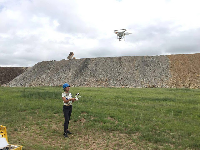
| Monitoring autonomous drone mission |
 |
| Mission completed Mavic Pro landed |
 |
| Download drone mission images for map generation |
Day 4 Drone Map Creation
Back to in house training in Baruun_Urt. Installation of OpenDroneMap application. Found that only 3 PC workstations had the power and performance to install and run ODM. An alternative approach was introduced using Microsoft Image Composite Editor which did not require high end workstations, however it only created a stitched mosaic from the air photo images. This meant that the trainees had to be taught to use QGIS Georeferencer GDAL plugin to georegister the map to a coordinate reference system on Day 5.
 |
| ODM & ICE Training |
Day 4 Mongolian Khorkhog Picnic
Well it was not all work and no play. The trainees decided to treat the teacher to a Mongolian Khorkhog celebration in the local river valley. One of the students received a goat which was sacrificed for our feast. This is a traditional Mongolian barbecue that is cooked in a container with hot stones and water.
https://en.wikipedia.org/wiki/Khorkhog
It was a clear dark night and I could see the stars brightly in the sky. It was quite an honour to be feted by my students this way. Naturally I had to drink lots of vodka and beer to 'help' with my digestion! Of course there is no feast if there is no communal singing.
Singing Mongolian folk songs is a key part of the event. It is a key social communal activity as part of the feast. Naturally I had to do my part. Thank goodness for mobile phones. I was able to download the lyrics for the Canadian folk song 'The French Song' by Lucille Starr. Fortunately my singing was so bad they did not ask me for another!
 |
| Naturally we had to have a fire as we prepared for the khorkhog feast |
Day 5 QGIS Georeferencer GDAL
I have to admit the last day was a little hard for the teacher who still had to deliver the training. However, it was successfully completed and the trainees got their certificates of completion.
 |
| Some had to leave for Ulaanbaatar on the last day. |
 |
Our trainees with their certificates
|
An orthophoto map of the Tsairt mineral open pit mine created from DJI Phantom 3 Pro flight mission. The site was too large to complete on one battery so the mission was undertaken in two flights autonomously.
 |
| Tsairt minerals open pit mine orthophoto map. |
Augusto Ribeiro
2018.08.20


hello. significant training. Thank you
ReplyDelete